Thursday 17 September 2009
Database update
Friday 11 September 2009
The Historic Environmental Record

The red crosses show 68 new records added to HER using the data collected this summer. Well done everybody - this is a real contribution to our local record.
To see more closely click on the image and it should open in a larger format that you will be able to read.
Monday 7 September 2009
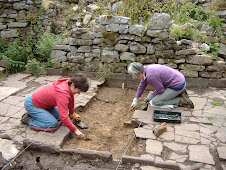
The final day - Monday 7th September
Over the weekend the team looked at the section around Pen-y-garn. This means that the south side of the valley has been surveyed from Pwyll Court to Y Neuadd. This represents about 1/4 of the total land area, so I estimate that it will take at least three more years to complete both sides, if we do just 15 days a year. In the next few weeks I will be putting out e-mails and letters to those who have offered to do a day or so each month so we can continue through the winter. It is easier to see features when the grass is low and we have identified a few places that it may be beneficial to excavate. Look out for news before the end of the month.
Jemma has continued to add records to the Historic Environmental Record. We must be up to 50 by now! Apart from adding to known sites we have also generated some research questions. There is a system of old routes along the valley, apart from the road, and there is a logical explanation as to why these exist. What is not so clear is why there is a trackway fairly close to the road why appears to be very old and passes under some of the field boundaries. It would be easy to speculate about this, but without hard evidence, which could be obtained by excavation, it would be little better than a guess.
I am hoping to organise a summing up meeting in the very near future to let everybody know what has been recorded and to give the opportunity for volunteers, residents and landowners to add anything they think is necessary to collective understanding of this beautiful, peaceful valley.
Thanks are due to everybody who has helped with the survey; the volunteers, residents and landowners. Without this kind of support a project like this would not be possible. If you have not been visited this year, please don't fret. We hope to continue and will include you next year.
Please come back to the blog as I will be adding to it in the future.
Friday 4 September 2009
Day 12 - Friday 4th September
The area covered this year amounts to about half of the identified study area. We are already working up a project design to look for funding for next year. Many people who have come along this year have asked if we will be continuing. The answer is yes. I am hoping to get volunteers together for about a day each month. There may be the opportunity to excavate or continue with the survey work as the weather allows. After Monday we can sit down and get our plans together. I will let you know via the blog and e-mail.
Jemma has started adding the new sites to the HER and we are on our way to the first 50. This data base is still under construction, but will be publicly accessible very soon. If you feel like a bit of fresh air tomorrow, meet us in the car park at 9.30.
Thursday 3 September 2009
Day 11 - Thursday 3rd September
At some time in the past the house now known as Nantyllaethdy has swapped names with another to the east, which is closer to the stream of that name. At some point one of these two houses was known as Tir Howell Sais, and one of them, probably Penywaun was shown on the 1587 map.
By looking at field boundaries and the remains of features in the landscape, alongside the old estate maps (1587 and 1760), tithe maps and early ordinance surveys we hope to be able to construct a history of each place we look at. This project is a marriage of history and archaeology because the documentary (historical) evidence can be supported and informed by the archaeological evidence (and vice versa).
We have been examining parts of the mountain wall, which is of indeterminate date and as yet we do not have documentary evidence to help us with this. This is a significant monument that separates the managed land from the mountain high above the Dyffryn Crawnon and the Claisfer valleys. The ability to date this wall, which must have been a major work, and therefore co-ordinated by some agency, would be a major breakthrough for our local historical record.
If you would like to see for yourself, we welcome volunteers. We will be working every day until next Monday. We meet at the car park opposite the village hall at 9.30 each morning. Come prepared for the showery weather and bring your lunch.
Wednesday 2 September 2009
End of week two

Jan is finally back in Llangynidr after living it up at the Council for Independent Archaeologists conference at Buxton. Meanwhile the team continued to ferret around. Jemma has started putting the new information onto the HER. Each red dot on the map is a new piece of information.
NEWSFLASH!!!
We have managed to gain access to the most exciting areas of the Dyffryn Crawnon!!
Thanks to Sue’s good efforts plus many helpers – the show on Sunday was a great success. We very very busy all day answering questions, looking up people’s farms on ancient maps and answering other general enquiries. One of our visitors, Mr Evans, was so impressed by the display and the information we are generating on the survey he has allowed us access to his land between Pantypaerau and Penygarn. This is a major breakthrough because it allows us to study some of the best-mapped areas in 1587 and we are very excited. It also means that we can survey a substantial block of the most interesting parts of the Dyffryn Crawnon. There are quite a few late medieval buildings on these maps and these may correspond to some of the unoccupied ruins marked on the 1st edition OS maps. This section of valley also holds some potentially very interesting information about the Mountain wall and we may be able to actually date a section of this wall for the first time! We are looking for some intrepid hill walkers, enthusiastic building recorders and good photographers for the last week. Many, many thanks to Mr Evans and all of the landowners who have participated in this project. See you all on Thursday – 9.30 in the car park!
Sunday 30 August 2009
Day 8 - Saturday 29th August
The mystery of Tyle Farm solved!
Intrepid explorers Kerry and Ann managed to burst through the back of hedge of Johnathon's garden at Tyle Barns. Johnathon was very interested in our survey and kindly showed Ann and Kerry some old photos of the barn he had renovated in very splendid style! I was very excited because it turns out that Tyle Barns was on the site of an extremely finely depicted mansion-house on the 1587 map and we were able to provide Johnathon with a copy of this map. His next-door neighbours in the bungalow at Tyle Isaf were quite rightly sceptical at first but the maps don't lie and they were delighted to be convinced that they were living on such an illustrious plot. It's not every day that you can tell people they are living on the site of a former late medieval mansion and it was great to be able to give them maps and other information - well done Ann and Kerry.
Today was Mikey's last day (good luck with 6th form!) - and he had a very fruitful day NOT finding two mills and a medieval chapel. Sometimes you have to accept that no evidence is a useful addition to the record - it seems that the mill has been washed away and the chapel (below Neuadd) is so overgrown that we should return in the Winter for another look. Thanks to David and Rodger!
Good luck to the Richardsons whose holiday finishes on Tuesday - thanks for all the coffee and good luck Chris with your thesis.
The whole team will be at the Agricultural show on Sunday. There will be no blog entry for that day. If you want to come along on Monday, meet at the car park at 9.30 in the morning. Happy surveying!
Friday 28 August 2009
Day 7 - Friday 28th August
Jemma writes: Today we investigated more of the fascinating Tyle Farm and also a ruined building known as Tir Bullock. The weather let us down occasionally, but the Richardson's obliged with coffee and fabulous views from their living room. Rodger has lead an excellent geophysical survey in the vicinity of Castle Farm with the able assistance of David and Michael. Results are enigmatic but no definite castle so far. The odds of there actually being a castle are looking good - we have yet to find it though!
Work will continue on Saturday.
If you want to see first hand what is happening the whole team will be at the Llangynidr Agricultural Show on Sunday.
Thursday 27 August 2009
Day 6 - Thursday 27th August

Wednesday 26 August 2009
Breaking news
If you would like to have a go, the link is below. Let Jan or Jemma know how you got on. We will feed back to CPAT.
http://www.herwales.co.uk/her/app/pub/
My first impression is that the search criteria are many and if you are looking for something specific you could miss it by entering the wrong term, even if its close. If you keep the search broad and get over 100 hundred hits you are restricted to the first 100 hits(letters ABC) and anything further down the alphabet cannot be accessed. Its a start, and as yet there are gaps in it, but the work we are doing is designed to help fill them, as well as to educate us. Overall its a useful tool and we should make every effort to contribute as much as we can.
Preparing for week 2
Some of you will be familiar with this map as its the one we mistakenly fitted to Pwyll Court!
Meet as usual at the car park at 9.30. New volunteers are always welcome. At least four of the first weeks workers have to go back to the day jobs, so any time you can spare will be brilliant.
Stop press - volunteer needed on Thursday to help with magnetometry. Will need to be totally metal free. I am told flip flops and pyjamas are the best outfit for the job. Those with hip replacements and bolts in their neck are ruled out sorry.
Monday 24 August 2009
Day 5 - Monday 24th August
On the subject of mills there is a reference to the Lord's mill in the manorial survey and another about 1km downstream from it on the Crawnon. Late in the afternoon a party set off to see what remains of these sites. At this time it is inconclusive, but again warrants further investigation and can be looked into.
The project has a two day break and will resume on Thursday. I would like to thank all those who have come along this week. Your input has been invaluable. I will put a notice in place on Wednesday when Jemma has decided the priorities for next week.
Breaking news - we have a volunteer who specialises in geophysics who will be working with us for a few days next week. Perhaps we can locate that illusive castle that Castle Road is named after (or kill the myth altogether!)
Sunday 23 August 2009
Day 4 - Sunday 23rd August
After a very civilised coffee break we split into three teams and set out field walking. Each group was able to report at least one site that was hitherto unrecorded by the end of the afternoon. There are several places which warrant closer examination and this will take place on Monday. Those without a head for heights, or weak legs need not apply.
On the other hand, if you are a "digger" there will be a job for you tomorrow!
For Monday's session, meet at the car park opposite the village hall at 9.30, or at The Neuadd at about 10.00. See yesterdays blog for directions. Thanks are due to the householders and landowner at the site for their tolerance and support.
Saturday 22 August 2009
Day 3 - Saturday 22nd August
Today was spent making records of ten features, mainly agricultural, that would have been overlooked and possibly lost in time. Our "finds" include a decorated stone gate post, several platforms and lynchets, remains of stone walls, a track and possibly a stone building. These will be reported to CPAT for the HER.
Later in the day we travelled up the valley to look for the more obvious sites and to get a "feel" for the terrain. Those who had not travelled this way before were amazed at the beauty and peacefulness of the valley. It is timeless.
On Sunday we will be working at the Neuadd. Meet 9.30 at village car park or 9.50ish at the Neuadd. Take the south side road up the Dyffryn. Just past the junction where the road returns along the north side of the valley turn in left and park near first cottage. You will see the blue truck.
Friday 21 August 2009
Day 2 - Friday 21st August
We will be returning to Pwll Court tomorrow to complete recording of the features found today. It has made us realise that even with a significant number of people the project as a whole is a monumental task. Thanks to everybody who turned out today. It was great to see more old friends.
Saturday - meet at village car park at 9.30 or Pwll Court entrance at 10.00. Look out for the blue truck parked inside the farm entrance.
Thursday 20 August 2009
Day 1 Thursday 20th August
After lunch we walked to a field site in Castle Road to assess how we might go about recording, and as the walk progressed ideas about the features we might like to cover, and the variety of methods we could use were generated. The walk continued on a triangular route back to top village where we took the opportunity to look at some of the older cottages and to look at Persondy Field, the site of excavations up to 2002.
Thank you to everybody who supported the first day. I look forward to day 2. As usual, meet in the car park opposite the village hall at 9.30. The focus for day 2 will be Pwyll Court and Court Farm. These can be found on the road from top village up the east side of the Dyffryn Crawnon. Walking from the church gate head up hill on the wider road and bear right in front of the Beaufort. Prepare for showers.
Wednesday 19 August 2009
The night before.....
Hopefully everything is now in place for the project. We have volunteers for every day, a talk to get us started, a leader with a vision, essential kit retrieved from its hiding place, initial research and documents to show us the way and permission to visit the majority of sites we are interested in - and a few others besides.
Personally I am looking forward to meeting those of you who are coming along for the first time, and to catch up with those who are old friends to Llangynidr History Society.
We start indoors tomorrow at the Red Lion (near the church for those who do not know the village). Dr. Bezant and Bob Sylvester are going to set the scene for us in an informal session, with coffee. After lunch we will be visiting a nearby site to practice recording and measuring.
For the remaining days - meet in the car park opposite the village hall at 9.30. Bring lunch and plenty of liquid refreshment and outdoor clothing appropriate to the weather conditions. We will return to the car park at around 4.30 each afternoon. For those who cannot come at the start of the day I will be posting venues on the blog so you will know where to find us if you come later.
Saturday 15 August 2009
Just 5 days to go before we start
On day one we will meet at 10.00 in the Red Lion to hear Bob Sylvester speak and to allow Jemma Bezant to give us information to get us started. On the subsequent days we will meet at 9.30 in the village car park, opposite the village hall. I will try to put details on the blog each evening so that volunteers who cannot join us at the start of the day will know roughly where to find us if they are coming later. Generally we try to take as few vehicles as possible to the sites as the roads are narrow and parking is very limited.
As a general rule volunteers will need stout shoes, plenty of liquid refreshment, a packed lunch, waterproof clothing if the weather dictates and sun protection. A mobile phone may be useful, but the reception is patchy and dependant on your network, so don't count on being able to get the cricket scores or being able to order a pizza delivery for lunch. A sense of humour is not compulsory, but it goes a long way in the rain.
We extend a warm welcome to those volunteers who are new to our summer projects and look forward to getting reacquainted with the weather beaten stalwarts who have passed this way before.
PS don't forget to add this blog to your favourites so you can find it easily in future.
Thursday 30 July 2009
Never mind the weather - its going to be great!
If you are thinking of getting involved, but need more information, please mail me with your questions. Do not be put off if you do not know anybody or other people seem to know what they are doing. I can reassure you that we all started with a little trepidation and more enthusiasm than knowledge. Best of all this is a great opportunity to get out into a very beautiful valley and enjoy the landscape, get some fresh air and learn a bit about the locality and its history - and its free (editors note - lose some weight as well). Age is no barrier - if you are under 110 we can find a task for you.
Don't be shy. Get in touch.
Tuesday 28 July 2009
Bob Sylvester (CPAT) will bring us up to date on his recent work in The Dyffryn Crawnon and talk to us about recording in the field.
Coffee will be provided.
There will be an opportunity in the afternoon for those who want to, to put some of the recording techniques into practice "in the field".
All welcome.
Tuesday 21 July 2009
training
Sunday 12 July 2009
The Dyffryn Crawnon Farm Project - 2009
In 1587 the lord of the manor decided to have maps drawn up to show his estates in South Wales. This included much of the village of Llangynidr and the surrounding countryside. These maps were amongst the first to be drawn to a common scale and are so good that features on the maps can be identified in the landscape today.
The aim of this project is to survey, in some detail, the farms in the Dyffryn Crawnon, a valley in the south west of the parish, and to evaluate the changes that have taken place in the last 430 years. The project is lead by Dr. Jemma Bezant of Lampeter University and will be carried out entirely by local volunteers. The information collected will be passed on to Clwyd Powys Archaeological Trust and recorded for the Archaeological Data Service.
In 2009 work will commence on 20th August until 7th September. If the need arises work may continue at intervals through the year until the whole area is covered.
Data will be collected mainly by field walking, topographical survey and geophysical survey.